AT A LEISURELY PACE ALONG THE PATHWAYS OF TRENTINO
An opportunity to discover nature as it awakens, to admire majestic landscapes and the numerous traces of human activity along these ancient routes, but also to experience the everyday life of the people of these valleys
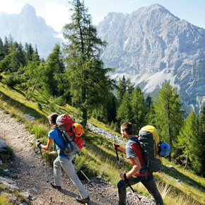
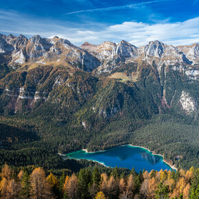
Some of the valleys in Trentino are criss-crossed by various paths, both secular and spiritual, some even on a “European” scale with origins in the heart of the old continent. They can also be walked all year round, but spring to autumn is definitely the best time of year to capture the most distinctive aspects of the areas they cover and the nature that welcomes those who walk them
San Vili
Affirming the notion that the mountains, as an alternate dimension of life, experiences and freedom, don’t begin at 1,500 metres, but – at least in Trentino – as soon as you leave the urban setting of the valley floor. This was the motivation behind the creation of the San Vili Trail, a walking route linking Trento to Madonna di Campiglio and the Adige Valley to the Brenta Dolomites, along alternative routes (ancient paths and new cycle paths) leading from the city to the mountains.
The path is about 100 kilometres long and largely follows the ancient Roman road that tradition has it was travelled, apparently in 405 A.D., by Vigilius, Bishop of Trent, and later by his remains after his martyrdom in Val Rendena. Created in 1988 by the SAT (Association of Trentino Mountaineers), the trail climbs up towards the Giudicarie and Rendena valleys, alternating between cart tracks through fields and forest roads, paths on panoramic ledges and walks through ancient villages, which are often little known and off the beaten track of mass tourism, but which offer hikers an important insight into the culture as well as opportunities to interact with local people.
The ideal starting point for the walk is Piazza Duomo in Trento, with its Romanesque cathedral that houses the remains of the martyr bishop, patron saint of the city. To the north of the city, the path crosses the Sorasàss bastion to enter the Valle dei Laghi and from there towards the southern slopes of the Brenta Dolomites; it then crosses the Vezzanese and the Banale, and ascend to the abandoned village of Iròn and to Passo Daone. From this point, the route continues along the valley floor of the middle and upper Val Rendena, to Carisolo and finally Madonna di Campiglio, following the route of the old road built in 1875.
In 2013, the itinerary was revised by the SAT Trails Commission and reintroduced with two routes: one “high” (110 km) – essentially the original route with more challenging gradients, suitable for experienced walkers – and the other “low” (106 km), which is easier and better connected to the available rest stops. The paths are partially separate and partially coincide, with the first divided into five stages and the second from five to seven. Like the most famous long-distance paths that cross Europe, the San Vili Way has a logo and a Credential to be stamped along the way. www.camminosanvili.it
Jacopeo d’Anaunia Way
At the end of the fifteenth century, according to an undocumented story but described in frescoes in various places of worship in Val di Non, some heads of families of the town of Fondo left for Santiago de Compostela as a vow for having been spared, together with their closest family members, from the plague epidemic of 1482. The Jacopeo d’Anaunia Way allows you to relive the pilgrimage experience by connecting the Basilica dei Santi Martiri Anaunensi in Sanzeno with the Sanctuary of San Romedio along a seven-stage route that spans both sides of the valley. There are two circular versions: a short one in 3 stages of around 60 km and a full one in 7 stages of around 160 km, using country roads through forests and apple orchards, as well as roads that run through the valley’s farming villages. The starting and finishing point is the religious heart of Val di Non, the village of Sanzeno. It was here in 397 A.D. that Sisinius, Martyrius and Alexander, the missionaries from Cappadocia sent by Vigilius, Bishop of Trent, to evangelise the populations of the valleys of the Noce, were martyred. The route is suitable for everyone; there are no hazardous stretches, but some physical preparation is required. It is entirely marked with signage bearing a stylised shell and yellow arrow.
The Via Vigilius also a route in stages inspired by Trentino’s martyr bishop and runs between the Monte di San Vigilio above Lana (Bz) and Trento. This path forms a link between South Tyrolean and Trentino culture, and this is particularly evident between S. Felice and Tret. In its diversity, it reveals a great richness.
San Rocco – Vallagarina Walk
The San Rocco Way is an itinerary in the lower Trentino region that unites the various wayside shrines in the municipalities of Mori, Ronzo-Chienis and Brentonico dedicated to the patron saint of pandemics, volunteers and pilgrims. It stretches between the Val di Gresta and the Brentonico plateau, areas in the Vallagarina that are devoted to caring for the landscape and sustainable agriculture, and where history, culture and nature intertwine along ancient paths and small, welcoming villages. Created by two local residents, this walk is a community project, which was immediately accepted and developed together with the SAT in Mori. It is a route that can be travelled all year round and in complete safety, and is a mixed route with stretches of path, dirt road and paved road. It has a total length of 70 km divided into 5 stages, with the start and end point in Mori. www.camminosanrocco.it
In every region of Italy, you can walk a Frassati Path, dedicated by the Club Alpino Italiano (CAI) to Pier Giorgio Frassati, the beatified Piedmontese mountaineer who died in 1925 at only 24 years of age.
The Trentino Frassati Path, inaugurated in July 2011, is the longest of all and stretches between the Sanctuary of the Madonna delle Grazie di Arco and the Sanctuary of S. Romedio in Val di Non. Conceived and created by the SAT, the walk covers seven stages. This route is not technically difficult and is walkable for most of the year. www.sat.tn.it/sentiero-frassati/
The Via Romea Germanica, recently recognised as a “European cultural route” by the Council of Europe, was born from the desire in several countries to revive the route that Abbot Albert Di Stade described in his pilgrim’s journal in 1200. It therefore has a solid historical basis and traces the locations he mentions. It is now a perfectly signposted route, which can be walked in its entirety (2,200 kilometres) in several stages. The Via Romea Germanica enters Italy at the Brenner Pass, crosses the Alto Adige-Südtirol and reaches Trento. It then heads towards the Valsugana, continuing to Bassano del Grappa and Padua.
Lastly, Trentino is crossed by the E5 European long-distance path, which leads from the Pointe du Raz in Brittany to Venice, via France, Switzerland, Germany and Austria. The Trentino section runs between the Valle di Cembra, Valle dei Mocheni and the Valsugana, the Vezzena, Lavarone and Folgaria Plateaux, the Pasubio Group and the Carega Group - Piccole Dolomiti (little Dolomites).
More information HERE


